


You’ve heard a lot about Nigeria’s six geopolitical zones, but what exactly are the states that make up the Middle Belt? This diverse region straddling north and south is home to some of the most scenic natural wonders and vibrant cultures in the country. Knowing the distinct identities of each state will help you appreciate the richness within.
In this post, we take you on a quick tour of the Middle Belt states. From the savanna grasslands of Benue to the mountain vistas of Plateau and everything in between, you’ll get a sense of what makes each state unique.
Overview of Geopolitical Zones in Nigeria
Geopolitical zones, often known as zones, are a form of administrative division that was created during the regime of President General Sani Abacha to group the country’s states.
Nigeria has 6 geopolitical zones based on ethnic groups and cultural similarities:
- North West consists of Kano, Kaduna, Katsina, Jigawa, Zamfara, Sokoto, and Kebbi.
- North East consists of Borno, Yobe, Adamawa, Gombe, Bauchi, Taraba
- North Central consists of Niger, Benue, Kwara, Kogi, Nasarawa, Plateau, FCT
- South West consists of Lagos, Ogun, Oyo, Osun, Ekiti, Ondo
- South South consists of Rivers, Cross River, Akwa Ibom, Delta, Edo, Bayelsa
- South East consists of Anambra, Imo, Abia, Enugu, Ebonyi
The Middle Belt refers to the North Central zone, with mostly Christian ethnic groups like Tiv, Idoma, and Igala. It’s a melting pot of over 200 ethnic groups and the food basket of Nigeria.
What Are the Middle Belt States in Nigeria?
The Middle Belt states are located in the central region of Nigeria. The following Nigerian states are generally considered to be part of the Middle Belt: Plateau, Nasarawa, Adamawa, Taraba, Niger, Kwara, Kogi, Benue, the Federal Capital Territory, alongside Southern Kaduna, Southern Bauchi, Southern Kebbi, Southern Gombe, Southern Yobe State, and Southern Borno.
The Middle Belt has a diverse landscape, from the Mambilla plateau to the Benue trough. It is home to over 200 ethnic groups, and over 500 languages are spoken. The region is known for lush farmlands, scenic hills and vibrant culture.
Full List of All Middle Belt States in Nigeria
The Middle Belt region of Nigeria comprises the central states in the country, distinct from the primarily Muslim north and Christian south. The Middle Belt states are ethnically diverse, with large minority groups like the Tiv, Idoma, Igede, Nupe, and Gwari. The Middle Belt States in Nigeria are:
- Plateau
- Nasarawa
- Adamawa
- Taraba
- Niger
- Kwara
- Kogi
- Benue
- Federal Capital Territory
- Southern Kaduna
- Southern Bauchi
- Southern Kebbi
- Southern Gombe
- Southern Yobe State
- Southern Borno.
Plateau State
Plateau state, located in the Middle Belt region of central Nigeria, has a long history and rich culture. With over 80 ethnic groups and over 50 languages spoken, Plateau State is one of the most diverse states in Nigeria; it is the twelfth largest state in Nigeria, spanning 30,913 km2 (11,936 sq mi).
Plateau State was created on 3 February 1976. The state capital is Jos, a city located on the Jos Plateau. Plateau state has a diverse landscape ranging from the Jos Plateau to river valleys. It’s known for stunning rock formations, waterfalls and the Jos Wildlife Park. It has a population of about 3.5 million people. The following indigenous ethnic groups are found in the state: Amo, Berom, Afizere, Aten, Anaguta, Bijim, Bogghom, Buji, Jipal, Mhiship, and Fier. People from various regions of the country, such as the Idoma, Igbo, Yoruba, Ibibio, Annang, Efik, Ijaw, and Bini, have also settled in the state.
The state has been inhabited for over 4,000 years and was home to many ethnic groups before the British created Plateau Province. The capital city, Jos, was officially founded in 1915. Plateau State is a predominantly Christian state and was once a center of tin mining. The beautiful landscape, natural wonders and cool climate make it a popular tourist destination. Shere Hills in the plateau state is Nigeria’s fifth highest point, with an elevation of 1,829 m (6,001 ft).
With its stunning natural beauty and rich history, Plateau State is a gem in the Middle Belt. Explore the rock formations, hike through lush forests and learn about the local tribes that have called this place home for centuries.
Federal Capital Territory
The Federal Capital Territory, commonly known as FCT, Abuja, is the capital city of Nigeria. Created in 1976, the FCT is a planned city built mainly in the 1980s based on a master plan developed by International Planning Associates (IPA), a consortium of three American planning and architecture firms led by Wallace, Roberts, McHarg & Todd (WRMT a group of architects), Archi Systems International (a subsidiary of the Howard Hughes Corporation), and Planning Research Corporation. Kenzo Tange, a Japanese architect, designed Abuja’s Central Business District. Abuja officially became Nigeria’s capital on 12 December 1991, replacing Lagos.
The FCT has an area of 1,476 km2 (570 sq mi) and a population of over 6 million people. Abuja is the eighth most populous city in Nigeria. Abuja comprises six area councils: Abaji, Abuja Municipal, Bwari, Gwagwalada, Kuje and Kwali.
Aso Rock, a 400-metre (1,300-foot) monolith left by water erosion, defines Abuja’s geography. To the south of the rock, the Presidential Complex, National Assembly, Supreme Court, and much of the city are located. Zuma Rock, a 792-metre (2,598-foot) monolith, is located immediately north of the city on the Kaduna Expressway. The Nigerian National Mosque and the Nigerian National Christian Centre are both important religious sites located in the FCT. Nnamdi Azikiwe International Airport is also situated in the FCT. Abuja is well-known for being one of Africa’s wealthiest and one of the few purpose-built capital towns.
The original inhabitants of the territory are the Gbagyi (Gwari) people who speak the Gbagyi (Gwari) language. Gwandara, Gbagyi (Gwari), and other indigenous peoples make up the majority of Abuja’s population. The Bassa, Gade, Dibo, Egburra, Nupe, and Koro are some of the other tribes in the area.
Adamawa State
Adamawa is a state in northeastern Nigeria, with its capital at Yola. Adamawa has a population of about 5 million people, it is the eighth largest area in Nigeria spanning across 36,917 km2 (14,254 sq mi). It takes its name from the historic emirate of Adamawa, with Yola, the emirate’s previous capital, acting as the state capital. With over 100 indigenous ethnic groups, the state is one of the most diverse in Nigeria.
Adamawa state was founded in the 1800s by the Fulani jihad and was partitioned between Germany and the British Empire during the Adamawa Wars. The British-controlled area was absorbed into the Northern Nigeria Protectorate, which ultimately became British Nigeria. It gained independence in 1961. The state’s economy depends on livestock and crops, although the Boko Haram insurgency has hampered its development. In 1961, the state was merged with Nigeria.
Originally, modern-day Adamawa State was part of the post-independence Northern Region until 1967, when the region was partitioned and the area became part of the Northeastern State. Gongola State was formed on 3 February 1976, along with 10 other states, after the Northeastern state was split in 1976. Gongola was divided fifteen years after statehood, with the state’s south becoming Taraba State and the north becoming Adamawa State.
For years, various ethnic groups have lived in Adamawa state, including the Bwatiye (Bachama), Bata (Gbwata), Gudu, Bali, Mbula-Bwazza, and Nungurab (Lunguda) in the central region; the Kamwe in the north and central region; the Jibu in the far south; Marghi, Waga, Kilba, and Wula in the north, and the Mumuye in the south. Adamawa state is also religiously diverse, with around 50% of the population being Sunni Muslim, 40% Christian (mostly Lutheran, EYN, ECWA, and Pentecostal), and 10% practicing traditional ethnic faiths.
Adamawa has one of the largest cattle markets in West Africa. The state is also home to several wildlife reserves, like Gashaka-Gumti National Park, that protect endangered species like chimpanzees, lions, and hippos.
The cultural diversity and natural beauty of Adamawa State make it an appealing place to visit. Exploring its mix of Christian, Muslim and indigenous beliefs provides insight into Nigeria’s complex religious fabric. From the historic Kingdom of Numan to the scenic Mount Dimlang, Adamawa offers a glimpse into the country’s vibrant heritage and stunning landscapes.
Benue State
Benue State has a long history, with archeological evidence showing human habitation from 9000 BCE. The state has a diverse population of over 4 million, with Tiv, Idoma and Igede as major ethnic groups. There are 23 Local Government Areas in the state. The state gets its name from the Benue River, Nigeria’s second-largest river after Niger. With a population of around 4,253,641 according to the 2006 census and a land area of 34,059 km2 (13,150 sq mi). Benue State was created as an administrative unit on 3 February 1976. It was one of the seven states established by the late General Murtala Mohammed’s military regime.
The state has fertile land, and an economy focused on agriculture. Benue State is known as the ‘Food Basket’ of the nation because of its agricultural production, especially yams, rice, beans, cassava, potatoes, maize, soybeans, sorghum, millet and sesame. The annual Benue Trade Fair showcases its agricultural produce and solid minerals. Benue is also Nigeria’s largest producer of oranges and mangoes and has large cattle ranching activities. Industrial activities include food processing, brewing, and mining of limestone, gypsum, kaolin, and lead-zinc.
Benue has a tropical climate with two distinct seasons: the dry season from November to March and the rainy season from April to October. The culture is vibrant, with annual festivals like the Igede Agba festival and Akata festival and traditional dances like Swange, Anjima, Adanma, Etam Ene, etc. Major languages are Tiv, Idoma, and Igede, with English as the official language.
The state capital is Makurdi, a bustling city on the banks of River Benue. Other major towns are Otukpo, Gboko, Kastina-Ala, etc. Benue State is a major agroecological zone in Nigeria, aptly nicknamed ‘the food basket of the nation’.
Kwara State
Kwara State was created on 27 May 1967 from the former Ilorin and Kabba provinces of the Northern Region and takes its name from the River Niger. Of all the states in Nigeria, Kwara is the ninth largest in an area spanning 36,825 km2 (14,218 sq mi). The capital and largest city in Kwara State is Ilorin. The state has a population of about 3.2 million people as of 2016, with most being Yoruba, Nupe, Bariba, and Fulani ethnic groups. The state capital is Ilorin, a major commercial center. Other major towns are Offa, Omu-Aran, Share, and Jebba.
The state has 16 Local Government Areas and three senatorial districts. Kwara State has two distinct vegetation zones: the southern Guinea savanna and the derived savanna. Ilorin and Offa are the most populated local government areas in Kwara. The dry season lasts from November to March, while the rainy season starts in April and ends in October. The state has a tropical climate with two distinct seasons.
The major economic activities are farming, fishing, and tourism. Major crops grown are yams, cassava, millet, rice, plantain, cocoa, cashew and kola nut. In the northern region of the state, there are several mineral resources, such as tourmaline and tantalite, as well as many mineral deposits. In the southern regions Oke – Ero, Ekiti, and Isin Local Government Areas, cocoa and kola nut are grown. The state is also known for wood carving, cloth weaving, and pottery. Some tourist attractions are the Esie Stone Images, Oke-Onigbin, Owu Water Falls, and River Niger.
Nasarawa State
Nasarawa State has a rich history and culture. The state was created on 1 October 1996 from neighboring Plateau State. Nasarawa’s capital city is Lafia; the state has 13 LGAs and a total population of over 2.5 million as of 2016, with a landmass of 26,256 square kilometres.
The major ethnic groups are Eggon, Gwandara, Alago, Hausa, Fulani, Tiv, Ninzo, Kofyar, Mada, Agatu, Gbagyi and Buh. The state’s official language is English, though other languages like Eggon, Gwandara, Alago, Agatu, Hausa, and Tiv are also commonly spoken. Nasarawa is also religiously diverse, with Muslims constituting around 61% of the state’s population and Christians and traditional ethnic religions constituting the remaining 39%.
The state is located in the north central region and has a mostly rural economy based on farming and fishing along the Benue River. Major crops are yams, cassava, guinea corn, rice, millet, sorghum, beans, maize, potatoes and cocoa. Other key industries in Nasarawa State, particularly in metropolitan areas, are animal herding and ranching of cattle, goats, and sheep. Mineral resources include coal, limestone, clay, iron ore, and salt. Some major towns in Nasarawa State are Lafia, the state capital, Akwanga, Keffi, Wamba, Doma, and Toto.
The state is home to the famous Farin Ruwa Waterfalls and has a good network of roads linking it to its neighboring states. Nasarawa State University is the first state-owned university in the state, located in Keffi town.
Kogi State
Kogi state was created on 27 August 1991 from parts of Niger, Kwara and Benue states. Kogi state is located in the central region of Nigeria. Kogi is the thirteenth largest, with a land area spanning 29,833 km2 (11,519 sq mi), and it is the twentieth most populous state in Nigeria, with an estimated population of 4.5 million as of 2016. Kogi state is known as the confluence state due to the confluence of Rivers Niger and Benue at its capital Lokoja.
The major ethnic groups are Igala, Idoma, Ebira, Agatu, Basa-Komo, Igbo Okun, Nupe and Gbagyi. The state’s major languages are Igala, Ebira, Okun, Bassa Nge, Nupe, Oworo, Ogori, Magongo, and Kakanda. The state is rich in mineral resources like coal, limestone, and iron ore. Major economic activities are farming, fishing, mining and tourism. Agriculture in Kogi state mainly consists of coffee, cashew, groundnut, cocoa, oil palm, and yam crops. Other key industries in the state are crude oil extraction and the livestock herding of cattle, goats, and sheep.
The popular cultural festivals are the Igala Cultural Festival and the Ebira Cultural Festival. The state has notable landmarks like the colonial Lugard House and Mount Patti.
Niger State
Niger State, located in the Middle Belt region of Nigeria, has a long and rich history. Niger State was formed on 3 February 1976, when the then North-Western State was divided into Niger State and Sokoto State. With a population of over 4 million across its 25 Local Government Areas, Niger State is home to several major ethnic groups like Nupe, Koro, Gwari, Kamuku, Dukawa, Boki, Jaba, Kambari, Dakarkari, Bassa, Pangu Tare, Gbagyi, and Hausa. The state has two dominant languages – Nupe and Hausa, with Nupe serving as the lingua franca.
Niger State is the largest state in Nigeria by area, spanning across 76,363 km2 (29,484 sq mi). The capital city of Niger State is Minna, a historic city that served as the capital of the British Niger Company. The state is named after the Niger River, which flows along the state’s western border. Niger State has a diverse landscape, from the rolling hills in the south to the savanna grasslands up north. It is also home to Kainji Lake National Park, a scenic wildlife reserve, and Gurara Waterfall.
The major economic activities in Niger State include farming, fishing and cattle rearing. Crops like yams, cassava, rice, millet, and beans are widely cultivated. Niger State is also known for handicrafts like pottery, weaving, blacksmithing and wood carving.
Taraba State
Taraba state was created on 27 August 1991 from the former Gongola State, with Jalingo as its capital. The state is named after the Taraba River which traverses the southern part of the state. It is the third largest state in Nigeria by Land area, spanning 54,473 km2.
Taraba state is located in the Northeast geopolitical zone of Nigeria, with a population of over 2.3 million people. The state has 16 Local Government Areas and over 77 distinct ethnic groups, including Jukun, Tiv, Kuteb, Chamba, Jibal, Mumuye, Mambila, Wurkum, Fulani, Jenjo, etc. The major languages are Jukun, Tiv, Mumuye, Fulfulde, Mambila etc. The state has diverse religious groups, including Christianity, Islam, and traditional African religions. The major languages spoken are Jukun, Tiv, Mumuye, and Fulfulde.
The state is home to the Mambilla Plateau, with stunning landscapes, waterfalls and temperate climate. Other attractions include the Gashaka-Gumti National Park, home to endangered species like chimpanzees and Cross River gorillas. Taraba State has huge agricultural and mineral potentials, with major crops like rice, maize, cassava, yam and cocoa. Minerals include kaolin, limestone, and barite.
The Middle Belt region of Nigeria also includes several other smaller areas like Southern Borno, Southern Adamawa, Southern Kaduna, Southern Gombe, Southern Bauchi, and Southern Yobe.
Southern Borno
Southern Borno is one of the states that make up the Middle Belt region of Nigeria. Historically, the area was inhabited by ethnic groups like the Kanuri, Shuwa, and Babur before the Fulani jihad of Usman Dan Fodio. The jihad led to the emergence of the Borno Empire, with the Kanuri as the dominant group. The major Ethnic Groups in southern Borno are the Kyibaku, Kamwe, Kilba, and Margi people. The state capital is Maiduguri, a historic city that served as the capital of the Borno Empire. The major religions are Islam and Christianity. Agriculture is the main economic activity, with crops like millet, sorghum, maize, and cotton cultivated. Cattle rearing is also popular, given the large presence of Fulani pastoralists.
Southern Kaduna
Southern Kaduna has a long history of diverse ethnic groups living together, though in recent decades, there has been increased conflict and violence in the region. Southern Kaduna consists of 12 Local Government Areas out of a total of 23 in Kaduna State.
Southern Kaduna is made up of various ethnic groups and subgroups that share a common culture and history. James (2000) divided these people into the following groupings based on their ethnolinguistic affinities under the theme “The Middle Belt (Composition of the Nok Culture Area)”: In 2016, the population of Southern Kaduna was about 4.5 million out of the total population of 8.5 million in Kaduna state. As a medium of communication, the common general language spoken in the area is Hausa.
Despite a history of conflict, Southern Kaduna remains an important agricultural region in Nigeria. The Kaduna River provides water for farming, and the area is known for crops like yams, cassava, millet, and tobacco.
Southern Gombe
Southern Gombe is made up of predominantly Christian ethnic groups like Cham, Dadiya, Jara, Kamo, Pero, Tangale, Tera, and Waja. Historically, the region used to be administered as part of the Bauchi emirate during the Fulani jihad of 1804 until 1976, when it became Gombe state. The discovery of tin ore deposits led to an influx of migrants into the region, especially the Tangale people.
Southern Bauchi
Southern Bauchi has a long and rich history. Originally inhabited by the Sayawa, Jarawa, and Gerawa ethnic groups, the area became a British protectorate in the early 20th century. Bauchi State consists of 20 local government areas with a population of over 6 million people.
The majority of Southern Bauchi residents are Christian, with large Catholic, COCIN, and ECWA denominations. Minority groups like the Sayawa, Jarawa, and Gerawa still maintain their traditional religious practices. Over 20 languages are spoken, including Hausa, Sayawa, Jarawa, and Gerawa.
Agriculture drives the economy, with crops like yams, cassava, millet, and sorghum. Cattle herding is also popular, and the region is known for handicrafts like pottery, weaving, and metalworking.
Southern Kebbi
Southern Kebbi is located in the southwestern part of Kebbi State, bordering Niger State. Historically, the area was part of the Sokoto Caliphate and a center of Islamic learning. The major ethnic groups are the Zuru, Kambari, Dukawa and Hausa.
The people of Southern Kebbi are predominantly farmers, growing crops like millet, guinea corn, maize, rice, beans, groundnuts and cassava. Fishing along riverine areas of the Meko, Dukku and Zuru is also common. Some important towns are Zuru, Dukku, Bunza, Sakaba, Koko, Ambursa and Arewa. The Emirate Council in Zuru is a significant political institution.
With a focus on agriculture and commerce, Southern Kebbi holds opportunities for trade and development. Its natural resources, cultural heritage and hospitable people attract visitors interested in eco-tourism, festivals and historical sites.
Southern Yobe
Yobe state, located in northeastern Nigeria, was created in 1991 from Borno State. The capital and largest city is Damaturu. The state is populated primarily by Kanuri, Fulani, and Hausa people.
Southern Yobe’s economy centers around agriculture, including the cultivation of millet, guinea corn, maize, beans, rice, and cotton. The state operates on sharia or Islamic law. The major ethnic groups of Yobe are predominantly Muslim.
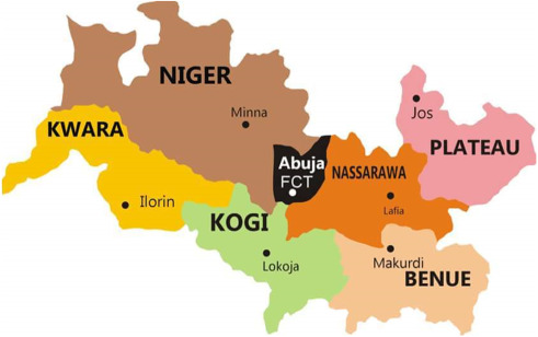
Middle Belt States Map
The Middle Belt region of Nigeria contains 15 states located in the central and north-central parts of the country.
Here’s a map showcasing all the middle belt states in Nigeria.
The Middle Belt states are diverse, with over 250 ethnic groups and more than 500 languages spoken across the region.
Frequently Asked Questions about Middle Belt States in Nigeria
Do you have questions about the Middle Belt states in Nigeria? Here are some common FAQs:
Where exactly is the Middle Belt located in Nigeria?
The Middle Belt refers to central Nigeria, between the predominantly Muslim north and the predominantly Christian south. It includes states like Benue, Plateau, Nassarawa, and Kogi.
What major ethnic groups populate the Middle Belt?
The major groups are the Tiv, Idoma, Hausa, Fulani, Igala, Igbo, Nupe, Jukun, Yoruba, and Kanuri people. There are over 250 ethnic groups and over 500 languages spoken in the Middle Belt.
Why is the Middle Belt region so diverse?
The Middle Belt lies along ancient migration routes, so many ethnic groups settled there. Its fertile land also attracted farmers from different areas.
What role does the Middle Belt play in Nigerian politics?
The Middle Belt is a swing region that can determine the outcome of national elections. Its diversity and mix of Christians and Muslims make its voting patterns complex and strategic.
What natural landmarks can be found in the Middle Belt?
Some key landmarks are the Jos Plateau, River Benue, River Niger, and Kainji Lake National Park. The region has forests, savannas and rivers that support agriculture and wildlife.
How many states are in the Middle Belt of Nigeria?
There are 18 states traditionally considered part of the Middle Belt region.
Is Edo South South or Middle Belt?
Edo state is usually considered part of the South South geopolitical zone, not the Middle Belt.
Is Kaduna part of the Middle Belt?
Parts of Kaduna state, especially Southern Kaduna, are considered part of the Middle Belt. The state straddles the boundary between the Middle Belt and the Muslim-majority north.
Conclusion
So there you have it, an overview of the Middle Belt states in Nigeria. While there may be ongoing debates about the exact number and boundaries, you now know the key details about each state in the region. The Middle Belt is a diverse, complex, and fascinating part of Nigeria with a rich history, culture, and natural beauty. Knowing the Middle Belt states is important to grasping the diversity within the country. Now, you’re equipped with information about the Middle Belt and can explore all it has to offer.