
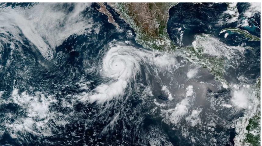
Major Hurricane Genevieve tore through the eastern Pacific this week, blowing past Category 4 and briefly touching Category 5 strength in one of the fastest intensification bursts the basin has seen in years. It’s the first storm to reach that top tier in the eastern Pacific since Hurricane Kristy back in 2024, and forecasters say it also marks the first major hurricane of the 2026 season across either the eastern Pacific or the Atlantic.
From Tropical Storm to Cat 5 in Two Days
Genevieve didn’t take long to turn into a monster. The system only became a hurricane on Saturday night, and by Sunday morning it was still a modest Category 3 with 120 mph winds. Less than 24 hours later, it had rocketed to 160 mph, earning Category 5 status early Monday with the National Hurricane Center clocking sustained winds of 155 mph and a central pressure of 929 hPa.
That kind of jump, from 80 mph to 160 mph in roughly 30 hours, is what meteorologists call rapid intensification, and it’s becoming a more familiar story in a Pacific basin that’s currently running unusually warm. Sea surface temperatures beneath Genevieve’s path were sitting around 86°F (30°C), well above the threshold hurricanes need to feed off, and the warmth wasn’t just skin-deep. Waters well below the surface were carrying plenty of extra fuel too, which helped the storm avoid the kind of upwelling that often slows down fast-moving cyclones.
Genevieve is now the fourth Category 5 storm recorded anywhere on the planet in 2026, joining Tropical Cyclone Horacio and the super typhoons Sinlaku and Bavi earlier in the year.
Where Genevieve Is Now, and Where It’s Headed
By Monday afternoon, Genevieve had already cycled back down to a strong Category 4 after entering what’s known as an eyewall replacement, a structural shake-up that’s common in storms this intense and often causes a temporary dip in strength before a possible second surge. At last check, the hurricane was centered about 520 miles south-southwest of the tip of Mexico’s Baja California peninsula, grinding northwest at a modest 13 mph.
The good news for anyone watching the forecast cones nervously: Genevieve isn’t expected to threaten land. No coastal watches or warnings are currently in effect anywhere along its path. The storm is on a track that keeps it well offshore, running roughly parallel to the Mexican coastline rather than curving toward it.
That doesn’t mean there’s zero impact on the ground. Genevieve is throwing off large swells that have already reached the southwestern coast of Mexico and are pushing into the southern Baja California peninsula. The National Hurricane Center has flagged a real risk of life-threatening surf and rip currents along those shores, so anyone near the beach in that stretch of coastline should keep an eye on local advisories even though the storm itself stays out at sea.
Genevieve’s Days Are Numbered
For all its punch, Genevieve isn’t going to hold onto Category 5 or even Category 4 strength for long. As it keeps pushing north and west, it’s heading straight into cooler water and drier air, the two things that essentially starve a hurricane. Forecasters expect sea temperatures along its path to drop below 77°F by Thursday, dipping under the 79°F mark that hurricanes generally need to survive. Mid-level humidity is expected to fall to around 50% over the same stretch, adding dry air into the mix that tends to choke off a storm’s structure.
Meteorologists still expect Genevieve to hang on as a major hurricane through at least Wednesday morning, but the broader outlook points to a steady weakening trend after that, with the system likely dropping below hurricane strength by Friday.
Genevieve isn’t traveling alone. Hurricane Fausto, which became the East Pacific’s first hurricane of the season before Genevieve’s rapid rise, is currently tracking toward Hawaii as a Category 1 storm. Forecasters expect Fausto to pass north of the islands rather than make a direct hit, but the National Hurricane Center is still warning of strong gusts and dangerous rip currents along exposed Hawaiian shorelines, so residents there are being told to keep monitoring updates even as the storm’s core stays offshore.
Between Genevieve and Fausto, the eastern Pacific has now produced six named storms this season, a pace that’s outstripping the Atlantic, which has managed just two so far. With ocean temperatures running warm and El Niño conditions expected to strengthen through the rest of the year, forecasters are bracing for the East Pacific to stay busy well into the coming months.