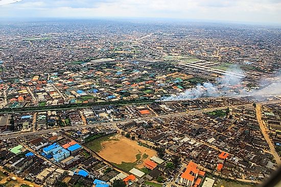
Nigeria is a country of immense geographical significance. Understanding Nigeria’s landmass is crucial to appreciating its role as the continent’s most populous nation and a major economic powerhouse. Nigeria’s terrain encompasses a rich tapestry of ecosystems, from lush rainforests to arid savannas.
In this article, you’ll discover the key features that define Nigeria’s physical geography, including its varied topography, extensive coastline, and the impact of its land area on the country’s development and regional influence. Prepare to delve into the complexities of Nigeria’s expansive territory and its far-reaching implications.
Nigeria Landmass
A landmass is a large, continuous area of land, typically surrounded by water or natural boundaries. Nigeria’s land mass refers to the total land area within its borders, encompassing a diverse range of geographical features and ecosystems.
Nigeria’s landmass covers approximately 923,768 square kilometers (356,669 square miles), making it the 32nd largest country in the world by land area. This vast expanse includes a variety of terrains, from coastal plains and tropical rainforests in the south to savanna grasslands and semi-arid regions in the north. The total area occupied by water in Nigeria is 13,000 km².
The Nigeria landmass is characterized by its rich geographical diversity. The country’s landscape includes:
- The Niger Delta, a vast wetland region in the south
- The Jos Plateau, a highland area in central Nigeria
- The Sahel region, bordering the Sahara Desert in the north
This varied topography contributes to Nigeria’s ecological richness and natural resource abundance, playing a crucial role in shaping the nation’s agriculture, economy, and cultural diversity.
Breakdown of Nigeria’s Land Regions
Nigeria’s landmass is diverse and expansive, encompassing a variety of geographical features that contribute to its rich ecological tapestry. The country’s terrain can be broadly categorized into several distinct regions, each with its own unique characteristics and importance to the nation’s geography and economy.
Coastal Plains
The southern part of Nigeria is dominated by coastal plains, a low-lying region that stretches along the Gulf of Guinea. This area is characterized by mangrove swamps, lagoons, and sandy beaches. The Nigeria landmass in this region is crucial for maritime activities and oil production, making it a vital economic zone.
Niger Delta
Further inland from the coast lies the Niger Delta, a vast network of wetlands and rivers. This region is not only ecologically significant but also economically important due to its rich oil reserves. The delta’s unique ecosystem plays a critical role in Nigeria’s biodiversity and environmental balance.
Central Plateau
Moving northward, the land rises to form the Jos Plateau, a significant highland area in central Nigeria. This elevated region boasts a cooler climate and is known for its scenic beauty and agricultural potential. The plateau’s distinctive topography sets it apart from the surrounding lowlands.
Savannas and Sahel
The northern part of Nigeria’s landmass transitions into savanna grasslands and eventually the semi-arid Sahel region. This area is characterized by its hot, dry climate and sparse vegetation. Despite challenging conditions, these regions are important for livestock grazing and certain types of agriculture.
The Geography and Climate of Nigeria
Nigeria’s land mass encompasses a diverse array of geographical features and climatic zones, making it one of Africa’s most ecologically varied countries. Spanning approximately 923,768 square kilometers, Nigeria’s landscape ranges from tropical rainforests in the south to arid savannas in the north.
Topographical Diversity
The Nigeria landmass is characterized by its varied topography. The southern coastal regions are dominated by mangrove swamps and tropical rainforests, gradually giving way to the Guinea savanna in the central regions. As you move northward, the landscape transitions into the Sudan savanna and finally the Sahel savanna near the border with Niger.
Climate Variations
Nigeria’s climate is equally diverse, influenced by its geographical position and topography. The southern regions experience a tropical monsoon climate with high rainfall and humidity, while the north has a hot, semi-arid climate with less precipitation. This climatic diversity contributes significantly to the country’s agricultural potential and biodiversity.
Impact on Biodiversity
The varied geography and climate of the Nigeria landmass support a rich tapestry of flora and fauna. From the lush rainforests teeming with exotic species to the expansive savannas hosting diverse wildlife, Nigeria’s ecological zones are home to numerous endemic species, making it a hotspot for biodiversity conservation efforts.
Nigeria’s Diverse Landscapes and Terrains
Nigeria’s landmass encompasses a rich tapestry of diverse landscapes and terrains, showcasing the country’s remarkable geographical variety. From coastal plains to rugged highlands, Nigeria’s topography offers a stunning array of natural features that contribute to its ecological richness and economic potential.
Coastal Regions and Lowlands
Along Nigeria’s southern border, the Atlantic coastline stretches for approximately 853 kilometers. This coastal zone features expansive mangrove swamps, lagoons, and sandy beaches. Moving inland, the Niger Delta region presents a complex network of creeks and rivers, forming one of the world’s largest river deltas.
Savannas and Plateaus
As you journey northward, Nigeria’s landmass transitions into vast savannas. The Guinea savanna, characterized by its tall grasses and scattered trees, gives way to the drier Sudan savanna. These grasslands play a crucial role in Nigeria’s agricultural sector.
Mountain Ranges and Highlands
Nigeria’s landscape is punctuated by several notable elevations. The Adamawa highlands in the northeast and the Jos Plateau in the center offer cooler climates and picturesque vistas. The Mambilla Plateau, Nigeria’s highest plateau, boasts lush vegetation and serves as a vital watershed.
This diverse Nigeria landmass not only shapes the country’s climate and ecosystems but also influences its cultural and economic activities, making it a land of remarkable contrasts and opportunities.
Nigeria’s Land Mass Compared to Other African Countries
Nigeria’s landmass is substantial, but how does it stack up against other African nations? Let’s explore this comparison:
- Algeria: Nearly four times larger than Nigeria’s landmass, spanning 2,381,741 square kilometres (919,595 sq mi). Algeria is the world’s tenth-largest nation by area, and the largest nation in Africa.
- Democratic Republic of Congo: About 1.3 times Nigeria’s size, spanning 2,345,409 km2 (905,567 sq mi).
- Sudan: Slightly larger than Nigeria, occupies 1,886,068 square kilometres (728,215 square miles), making it Africa’s third-largest country by land area.
- Libya: Approximately 1.7 times Nigeria’s area, spanning 647,183 square miles (1,759,540 square kilometers). It is the fourth-largest country in Africa.
- Chad: About 1.2 times the size of Nigeria, covers an area of 1,284,000 square kilometres (496,000 sq mi).
- Niger: Marginally larger than Nigeria. Niger covers a land area of almost 1,270,000 km2 (490,000 sq mi), making it the largest country in West Africa.
- Angola: Slightly bigger than Nigeria. The total land size is 1,246,700 km2 (481,400 sq mi).
- Mali: Slightly bigger than Nigeria’s landmass, spanning 479,242 sq mi (1,241,238 sq km).
- South Africa: 32% larger than Nigeria. The total land area is 1,220,813 km2 (471,359 sq mi).
- Ethiopia: Roughly 10% larger than Nigeria. Ethiopia covers a land area of 1,104,300 square kilometres (426,400 sq mi)).
While Nigeria boasts a significant landmass, it’s not the largest country in Africa. However, it’s important to note that Nigeria’s land area is diverse, encompassing various ecosystems from tropical rainforests to savannas. This variety contributes to Nigeria’s rich biodiversity and natural resources, making its landmass particularly valuable despite not being the continent’s largest.
Frequently Asked Questions
These are some frequently asked questions and answers about Nigeria landmass.
What is Nigeria’s total land area?
Nigeria covers a total land area of approximately 923,768 square kilometers (356,669 square miles), making it the 32nd largest country in the world by land area.
What are the main geographical features of Nigeria?
Nigeria’s diverse landscapes include coastal regions, lowlands, savannas, plateaus, mountain ranges, and highlands, such as the Adamawa highlands, Jos Plateau, and Mambilla Plateau.
How does Nigeria’s climate vary across its landmass?
Nigeria experiences a range of climates, from the humid tropical climate in the coastal regions to the semi-arid conditions in the northern savannas. The highlands and plateaus often have cooler temperatures due to their elevation.
What are some notable rivers and water bodies in Nigeria?
The Niger River, one of Africa’s major rivers, flows through Nigeria, along with other significant rivers like the Benue, Cross River, and Kaduna River. The Niger Delta is a vast coastal region characterized by a network of creeks and rivers.
How does Nigeria’s landmass impact its economy and culture?
Nigeria’s diverse landscapes and ecosystems influence its agricultural practices, natural resources, and cultural traditions. The savannas support livestock rearing, while the coastal regions and highlands offer unique biodiversity and tourism opportunities.
How does Nigeria’s landmass compare to other African countries?
In terms of land area, Nigeria ranks as the 14th largest country in Africa. While its Nigeria landmass is substantial, it’s smaller than countries like Algeria, the Democratic Republic of the Congo, and Sudan. However, Nigeria’s population density is much higher than many of its larger neighbors, making efficient use of its available land crucial for sustainable development.
What are the major geographical features of Nigeria’s landmass?
The Nigeria landmass boasts a variety of geographical features. The country’s landscape includes the Niger Delta in the south, expansive savannas in the north, and the Jos Plateau in the central region. These diverse ecosystems contribute to Nigeria’s rich biodiversity and natural resources, shaping the nation’s agriculture, economy, and cultural practices across its extensive territory.
By understanding Nigeria’s landmass and its geographical features, we can better appreciate the country’s natural diversity, environmental challenges, and the role its landscapes play in shaping its economy, culture, and overall development.
Conclusion
As you’ve discovered, Nigeria’s landmass is a diverse and expansive territory that plays a crucial role in the country’s identity and development. Understanding the size, and geography of Nigeria’s land provides valuable context for appreciating its challenges and opportunities. From the lush rainforests of the south to the arid Sahel region in the north, Nigeria’s varied landscape shapes its economy, culture, and future prospects.
By grasping the significance of Nigeria’s landmass, you gain deeper insights into this influential West African nation. As Nigeria continues to evolve, its land will remain a defining feature and vital asset in its journey toward progress and prosperity.
Discussion about this post