
Along the edge of Lagos where the Atlantic Ocean meets one of Africa’s fastest growing cities, a major battle over the future of the coastline has been quietly building for years. Behind the luxury resorts, reclaimed lands, waterfront businesses, and ambitious infrastructure plans lies a deeper struggle involving development, investment, government authority, and control of one of Nigeria’s most valuable spaces.
For decades, Lagos has looked toward the ocean as both a challenge and an opportunity. The Atlantic has threatened the city through erosion and flooding, yet it has also created new possibilities for expansion, tourism, real estate, and economic growth.
The controversy surrounding Lagos’ coastal development did not begin with one project or one decision. It emerged from years of transformation that changed how the city interacts with its shoreline, bringing different interests into the same space and raising questions about who determines the future of the coast.
The dispute that captured public attention may have focused on one beach, but the story behind it stretches far beyond the shoreline. It is a story about power, development, and the battle over who gets to shape the future of one of Nigeria’s most important cities.
When Lagos began its fight against the Atlantic Ocean
Before the debate over highways, beaches, and private developments, Lagos was already facing a serious battle with nature. The city’s relationship with the Atlantic Ocean has always been complicated because the same water that created economic opportunities through trade and tourism also threatened the stability of coastal communities through erosion and flooding.
The city’s coastline had suffered decades of erosion, particularly around areas such as Bar Beach in Victoria Island. Ocean currents gradually threatened sections of land that were economically important to Lagos’ commercial centre, creating concerns about the future safety of one of the city’s most valuable districts.
The challenge forced government planners and investors to consider a more ambitious solution. Instead of only defending existing land, the idea of creating new land from the Atlantic Ocean emerged as a possible answer. This approach represented a major shift in how Lagos viewed its coastline, moving from simply protecting the city against the ocean to exploring how the ocean could become part of the city’s future expansion.
This vision eventually produced Eko Atlantic, one of the most ambitious coastal developments in Africa. The project was conceived in 2003 through a partnership involving Lagos State Government and South Energyx Nigeria Limited, with the aim of creating a new urban district while also providing coastal protection against erosion affecting Victoria Island and surrounding areas.
By 2008, construction of the Great Wall of Lagos had begun. The massive coastal defence system became the foundation for protecting the shoreline while supporting the creation of new reclaimed land from the Atlantic Ocean. The project represented one of the most significant attempts in Nigeria’s history to reshape the relationship between a major city and its coastal environment.
The project represented a major change in how Lagos viewed its relationship with the ocean. The Atlantic was no longer seen only as a threat that needed to be controlled. It became a resource that could be transformed into economic opportunity, new urban spaces, and future investment possibilities.
However, the transformation also created questions that would become increasingly important years later. When land is created from the sea, who controls it? Who decides how it should be developed? Who benefits from the transformation? Those questions would eventually return to the centre of Lagos’ coastal disputes as new projects and competing interests emerged.
Eko Atlantic and the birth of Lagos’ coastal ambition
Eko Atlantic became a symbol of Lagos’ ambition to compete with major coastal cities around the world. The project introduced a vision of a new financial district built on reclaimed land, with modern infrastructure, luxury properties, and a new commercial identity for Lagos. It represented the belief that the city could overcome geographical limitations and create new opportunities by transforming its relationship with the Atlantic Ocean.
By 2013, the development had made significant progress, with millions of square metres of reclaimed land created from the Atlantic Ocean. The project attracted attention from investors who saw Lagos’ coastline as a place where new economic opportunities could emerge, particularly as demand for premium real estate and modern business districts continued to grow.
For Lagos, the development represented confidence in the city’s future. It showed that the city was willing to challenge geographical limitations and create new spaces for business, housing, and investment. The project became part of a broader vision of Lagos becoming a global commercial hub capable of competing with major cities around the world.
But the expansion of coastal development also created a complicated reality. The more valuable the shoreline became, the more important questions about control, regulation, access, and development rights became. A coastline that once represented an environmental challenge had become one of Nigeria’s most valuable economic assets.
Different interests began moving toward the same space. Government agencies wanted infrastructure that could support economic growth. Investors wanted protection for their businesses and certainty about the future. Developers wanted clear regulations that would allow long term planning. Communities wanted access, security, and assurance that development would not leave them behind.
The coastline was becoming a place where different visions of Lagos were beginning to compete.
The rise of Lagos’ waterfront economy
The transformation of the coastline continued beyond Eko Atlantic. Areas around Victoria Island, Lekki, and neighbouring coastal communities became some of the most attractive locations for real estate, entertainment, and tourism businesses. The waterfront gradually developed into one of Lagos’ strongest economic zones, attracting investors who saw opportunities in the city’s growing population and demand for leisure experiences.
Private developers invested heavily in waterfront projects, including hotels, restaurants, resorts, and beach destinations. The attraction was obvious because a beachfront location in Lagos offered business opportunities connected to tourism, entertainment, lifestyle, and hospitality. The coastline became associated with luxury experiences, premium investments, and the image of a modern Lagos.
Among the developments that gained national recognition was Landmark Beach, which became one of Lagos’ most popular leisure destinations. The project represented the growing importance of private coastal businesses in Lagos’ economy and became a meeting point for entertainment, hospitality, commercial activity, and social experiences.
However, the rapid growth of waterfront businesses created a new challenge. Many of these developments existed in areas that were also important for future government infrastructure plans. The same coastline that had attracted private investment was also becoming increasingly valuable for transportation and national development projects.
Lagos had encouraged coastal investment, but the Federal Government still had responsibilities involving major national projects. The coastline was becoming a place where state development plans and federal infrastructure ambitions could eventually collide.
The Federal Government’s coastal highway vision changes the conversation
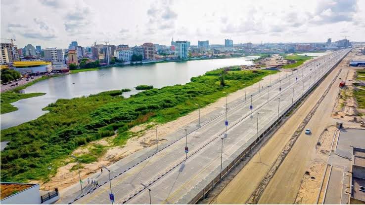
The biggest turning point came with the Lagos Calabar Coastal Highway, a project that transformed the conversation around Lagos’ coastline from one focused mainly on private development and urban expansion into a much larger debate about national infrastructure, government authority, and the future direction of Nigeria’s coastal economy. The highway was announced as one of Nigeria’s largest infrastructure developments, designed to connect Lagos with Cross River through coastal states and create a major transportation corridor along the southern coastline.
The proposed highway was expected to improve transportation, create economic opportunities, strengthen coastal connectivity, and support new development along the southern corridor. For the Federal Government, the project represented a national economic strategy aimed at unlocking the potential of Nigeria’s coastal regions while improving movement between major economic centres.
For Abuja, the coastline was not viewed only as Lagos property. It was considered part of a wider national transportation and development network that could influence trade, tourism, logistics, and regional connectivity. The Federal Government’s position was that strategic infrastructure projects required long term planning beyond individual locations or private interests because projects of such scale were designed to serve wider national objectives.
However, the route of the highway placed it directly within one of Lagos’ most valuable commercial areas. The project was entering a coastline that already contained major businesses, private developments, hospitality destinations, and investments built over several years. The challenge was that the space had already become economically important before the arrival of the federal infrastructure plan.
This created the central tension. A federal infrastructure project was moving through a space that Lagos had spent years developing as a commercial waterfront. The question became how to balance national infrastructure priorities with existing coastal investments, especially when private businesses had built their operations around locations they believed represented long term opportunities.
The highway therefore became more than a road project. It became the point where years of coastal development decisions, government responsibilities, and private investments finally came face to face.
Landmark Beach becomes the face of the dispute
The controversy gained national attention in 2024 when sections of Landmark Beach became affected by plans for the Lagos Calabar Coastal Highway. What started as a disagreement surrounding one development quickly became a national conversation about the future of Lagos’ coastline and the relationship between government projects and private investments.
Landmark Beach represented the wider concerns of private businesses operating along Lagos’ coastline. The development had become one of the city’s most recognised leisure destinations, attracting visitors while supporting businesses connected to hospitality, entertainment, and tourism.
The company argued that the development was a major tourism investment that supported businesses, employment, and economic activity. The concerns were not only about a physical location but also about the wider economic network that had grown around the beach environment over time.
The Federal Government maintained that the highway was a national infrastructure project and that areas required for construction had to be made available. Officials argued that projects of such importance required access to designated routes and that national development priorities could not be ignored.
Minister of Works Dave Umahi defended the project, arguing that the affected area fell within the highway corridor and questioning claims surrounding ownership and development rights. His position reflected the Federal Government’s broader argument that strategic infrastructure projects must move forward despite existing developments along proposed routes.
The dispute exposed the complicated relationship between approvals granted by state authorities and federal powers over national infrastructure. A business could operate legally within Lagos’ planning system while still being affected by a federal project because different levels of government operate with different responsibilities.
That reality turned the beach dispute into a much larger conversation about coastal governance, development planning, and the future management of Lagos’ shoreline.
The struggle over who controls Lagos shoreline
The coastal dispute revealed the overlapping responsibilities that exist along Lagos’ waterfront. The controversy showed that managing the coastline involves several layers of authority, each with different interests and responsibilities that can sometimes come into conflict.
Lagos State has significant influence over urban planning, development approvals, and the direction of the city’s expansion. The state has spent years shaping a vision for Lagos as a global city where waterfront areas contribute to economic growth, attract investment, and support the development of a modern urban environment.
The Federal Government, however, has authority over national highways, strategic infrastructure, and aspects of maritime regulation. From Abuja’s perspective, coastal areas connected to major national projects cannot be viewed only through the lens of state development plans because they also serve wider national purposes.
The coastline therefore exists within a complicated space where different powers meet. It is an area where local planning decisions, private investments, environmental concerns, and federal infrastructure responsibilities all overlap.
The Federal Government’s warning to some shoreline developers in Lagos to regularise their developments reinforced the argument that coastal activities involve more than state level approval. The move showed that control of Lagos’ coastline was becoming a major issue of national importance because the shoreline had grown into an area of enormous economic and strategic value.
The dispute was no longer only about construction. It became about governance, authority, and who has the power to shape the future of the Atlantic corridor.
Flooding turns the coastal battle into an environmental issue
The argument surrounding Lagos’ coastline eventually moved beyond ownership, development rights, and infrastructure planning. The conversation expanded into a bigger concern about the environmental consequences of reshaping a city that has always lived close to water.
Lagos has a unique geographical challenge because large parts of the city sit close to sea level, with a network of lagoons, creeks, and waterways connecting urban communities directly to the Atlantic Ocean. This natural environment has always made coastal planning sensitive because changes made in one area can affect drainage patterns, water movement, and the safety of surrounding communities.
As major projects continued along the shoreline, concerns grew around reclamation activities, dredging, coastal barriers, and the long term impact of changing the natural structure of the coast. The Lagos Calabar Coastal Highway became part of that wider discussion because it involved major construction within an environment already vulnerable to flooding and erosion.
The Federal Government maintained that the project was designed with engineering solutions aimed at managing drainage challenges and reducing future risks. Officials argued that the highway included systems intended to address flooding concerns rather than create additional environmental problems.
However, the environmental discussion showed that Lagos’ coastal future could not be determined only by economic calculations. The Atlantic shoreline is not simply a location for roads, buildings, and businesses. It is also a natural system that supports communities, ecosystems, and the city’s ability to manage water.
The challenge facing Lagos is finding a balance between transformation and protection. The coastline can create enormous economic value, but poor planning can also create consequences that affect millions of residents across the city.
The real Federal and State power struggle behind the coastline
At its core, the Lagos coastal dispute is about authority and the question of who has the strongest influence over decisions that shape one of Nigeria’s most valuable economic spaces. The controversy surrounding the beach project and the coastal highway exposed a deeper issue that had been developing for years: the challenge of managing a coastline where federal responsibilities, state planning powers, and private investments all meet.
The Federal Government views the coastline as part of a national development strategy where major infrastructure projects can transform economic activity across the country. From this perspective, the Atlantic corridor is not only a Lagos asset but a national resource that can support transportation, trade, tourism, and regional connectivity.
Lagos State, however, views the coastline through the lens of urban development and city planning. The state has spent years building a vision of Lagos as a modern global city where waterfront areas contribute to economic growth, attract investment, and support the city’s expanding population.
Both positions are connected to different responsibilities, but they naturally create tension when they overlap in the same location. The Federal Government’s priority is national connectivity, strategic infrastructure, and economic expansion, while Lagos State’s priority is managing the growth of a city that already carries enormous economic importance for Nigeria.
The disagreement is therefore not simply about a beach, a road, or a single construction project. It is about how power is shared when national ambitions meet local development plans. The coastline has become the place where those competing visions are most visible.