
Rain clouds have once again settled across much of Nigeria, bringing familiar fears into homes, markets, schools, farms, highways, coastal communities, busy cities, quiet villages, leaving many families watching the skies with growing concern as the rainy season gathers strength. Every passing day carries fresh expectations, fresh warnings, fresh preparations, while memories of previous flood disasters continue to shape how millions of Nigerians respond whenever heavy rainfall begins to fall across different parts of the country.
June 2026 has already produced scenes that remind many people how quickly ordinary rainfall can become a national concern, especially where drainage systems struggle to cope or rivers begin rising beyond their normal levels. Several communities have already experienced the first visible impact, while many more remain under close observation as weather agencies continue issuing alerts ahead of the months that traditionally record the country’s highest flood activity. Those early developments have created a picture that is still unfolding, making every forecast, every rainfall report, every river level update increasingly important as Nigeria moves deeper into the rainy season.
Nigeria enters another critical flood season
Nigeria’s annual flood cycle follows a pattern that usually becomes more pronounced between July, August, September, occasionally extending into October depending on rainfall intensity across the country. Although heavy rainfall begins earlier in several southern states, widespread flooding often develops gradually before reaching its highest levels during the middle months of the rainy season.
Authorities had already warned before the arrival of June that 2026 could present significant flood risks across dozens of states because of projected rainfall, overflowing rivers, blocked drainage systems, rapid urban development, rising sea levels along coastal communities, increasing pressure on existing flood control infrastructure. Those warnings encouraged state governments, emergency agencies, local authorities, community leaders to begin preventive measures long before widespread flooding became a reality.
Despite those nationwide alerts, the actual flood situation as of 3 July 2026 remains concentrated within only a handful of states. Many others continue operating under precautionary warnings rather than confirmed large scale flooding, creating a situation where preparation remains just as important as emergency response.
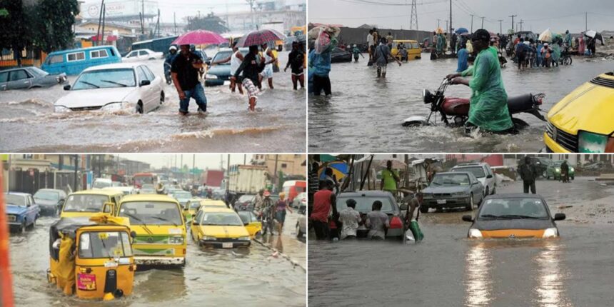
Lagos becomes Nigeria’s flood hotspot
Among every state monitored during June 2026, Lagos has clearly emerged as the country’s most seriously affected location. Heavy rainfall that began on 28 June continued into the following days, overwhelming drainage channels across several parts of the state despite ongoing flood control projects carried out over recent years.
Many roads became almost impossible to use as floodwaters covered major transport corridors, forcing thousands of commuters to spend several extra hours attempting to reach workplaces, schools, businesses, hospitals, homes. Commercial activities slowed significantly across various business districts as shop owners struggled to protect goods from rising water while customers remained unable to move freely across affected locations.
Weather conditions also created challenges beyond road transportation. Poor visibility combined with persistent rainfall contributed to disruptions affecting some flight operations, adding another layer of inconvenience for travellers. Electricity supply experienced temporary interruptions within certain locations after floodwaters affected infrastructure before services gradually returned.
Local authorities responded by increasing emergency monitoring, clearing blocked drainage channels, deploying response teams to vulnerable communities, while reminding residents to avoid driving through flooded roads or dumping refuse into drainage systems that were already operating beyond normal capacity.
Communities facing the greatest impact
Floodwaters spread across numerous parts of Lagos rather than remaining isolated within a single district. Communities including Lekki, Victoria Island, Ikoyi, Lagos Island, Ikota, Ajah, Surulere, Ikeja, Alimosho, Agege, Ikorodu, Badagry, Epe all experienced varying degrees of flooding as rainfall continued placing enormous pressure on existing drainage infrastructure.
Several residential neighbourhoods watched water gradually move from gutters into streets before reaching compounds, creating difficult conditions for homeowners trying to protect furniture, electrical appliances, vehicles, household belongings. Commercial centres also experienced reduced customer activity because movement across flooded roads became increasingly difficult throughout periods of heavy rainfall.
Traffic congestion quickly became one of the most visible consequences. Vehicles moved slowly across roads that remained partially submerged while alternative routes also became crowded as motorists searched for safer passages. Daily routines that normally required less than 1 hour suddenly consumed several hours, affecting productivity across both public, private sectors.
Lagos State authorities later approved emergency dredging across 28 additional drainage channels as part of efforts designed to improve water movement before heavier rainfall expected between July, September reaches its seasonal peak.
Rivers records localized flooding
Rivers State has also experienced localized flooding during the opening phase of the rainy season although conditions remain considerably less extensive than those recorded across Lagos. Persistent rainfall has affected several low lying communities where drainage challenges, natural geography make flood development more likely whenever heavy rain falls over extended periods.
Residents living within vulnerable riverine communities remain particularly alert because seasonal flooding often intensifies later during July, August as river levels continue rising. Emergency officials have therefore focused not only on responding to current conditions but also preparing communities for possible changes should rainfall become heavier during the coming weeks.
Urban flooding within Rivers has remained largely localized rather than widespread, allowing authorities greater opportunity to monitor developing situations before larger emergencies emerge. Continued rainfall, however, means conditions could change quickly depending on weather patterns recorded throughout the remainder of the rainy season.
Bayelsa watches rising water levels
Bayelsa’s relationship with flooding differs from many inland states because much of its geography naturally exposes communities to rivers, creeks, tidal influences, seasonal water movement. Rising water levels during early July have already produced localized flooding across several coastal, riverine communities as rainfall continues increasing across southern Nigeria.
Government officials have intensified public awareness campaigns encouraging residents not to block drainage channels while also reminding vulnerable communities to remain attentive to emergency information issued throughout the rainy season. Those preventive efforts aim to reduce avoidable flooding caused by human activities while strengthening readiness for possible river flooding later during the season.
Historical experience continues shaping preparations across Bayelsa because previous rainy seasons have shown how localized flooding can gradually develop into more widespread river flooding whenever sustained rainfall combines with rising upstream water levels.
States under official flood alert
Although only a limited number of states have confirmed notable flooding as of 3 July 2026, official warnings currently extend across many more parts of Nigeria. Those alerts reflect weather forecasts rather than existing disasters, providing governments, residents valuable time to prepare before conditions potentially worsen.
States currently receiving heightened attention include Akwa Ibom, Cross River, Ondo, Ogun, Oyo, Ekiti, Kwara, Kogi, Benue, Niger, Kaduna, Plateau, Nasarawa, Adamawa, Taraba, the Federal Capital Territory. Each location remains under close observation because continued rainfall could rapidly change local conditions depending on drainage capacity, river behaviour, rainfall intensity, surrounding geography.
Flood alerts should never be mistaken for confirmed disasters. Rather, they represent an opportunity for preparedness, allowing emergency agencies to mobilize resources before situations become critical while encouraging residents within vulnerable communities to remain informed throughout the rainy season.
Federal warning covering 26 states
Additional federal flood advisories issued for the period between 22 June 2026, 5 July 2026 expanded attention across a broader section of the country. Those warnings included Abia, Adamawa, Akwa Ibom, Anambra, Bayelsa, Benue, Cross River, Delta, Ebonyi, Edo, Ekiti, Enugu, Imo, Kogi, Kwara, Lagos, Niger, Ogun, Ondo, Osun, Oyo, Rivers, Nasarawa, Plateau, Taraba, Kebbi, alongside high risk communities within the Federal Capital Territory.
Such nationwide advisories illustrate that flood forecasting depends upon projected rainfall rather than confirmed flooding. Conditions within many listed states remain stable despite official warnings because forecasts simply indicate elevated risk should heavy rainfall continue during the coming weeks.
Early warning systems therefore play a crucial role by providing valuable preparation time instead of waiting until communities already face dangerous flooding.
Why flood risks remain high
Several environmental factors continue increasing flood risks across Nigeria despite ongoing investments in drainage improvements, river management, emergency preparedness. Heavy seasonal rainfall remains the primary driver, yet urban expansion has also contributed significantly as more natural water absorption areas become covered by buildings, roads, paved surfaces.
Blocked drainage systems further reduce the ability of cities to remove storm water quickly during prolonged rainfall. Refuse dumped into gutters frequently restricts water movement, causing streets that might otherwise remain passable to flood within relatively short periods.
Coastal states face additional pressure from tidal influences that can slow drainage during periods of exceptionally high sea levels. Where intense rainfall coincides with high tides, floodwaters often remain trapped for longer periods before eventually receding.
Riverine communities experience another unique challenge because rising rivers may overflow their banks after receiving water flowing downstream from distant locations that experienced heavy rainfall several days earlier.
Urban communities face growing pressure
Rapid population growth across major Nigerian cities continues placing increasing pressure upon infrastructure originally designed for much smaller populations. Expanding residential estates, commercial developments, transport projects have altered natural drainage pathways while simultaneously increasing the amount of surface runoff produced during storms.
Lagos provides perhaps the clearest example because densely populated districts combine limited open spaces with extensive paved surfaces that prevent rainwater from naturally soaking into the ground. Similar patterns continue emerging within other growing cities where urbanization often progresses faster than drainage expansion.
Climate variability may also contribute to heavier rainfall occurring within shorter periods, increasing pressure on drainage systems even where maintenance efforts remain ongoing. Such conditions require continued investment not only during emergencies but throughout the year.
Communities living closest to danger
Low lying communities traditionally remain among Nigeria’s most vulnerable locations whenever heavy rainfall intensifies. Residents within river basins, coastal settlements, wetlands, poorly drained urban neighbourhoods often experience flooding before surrounding areas because water naturally collects within those landscapes.
Families living beside rivers usually monitor changing water levels closely throughout the rainy season, particularly after several consecutive days of rainfall. Fishermen, farmers, traders frequently possess valuable local knowledge developed through many years of observing seasonal water behaviour, allowing them to recognize early warning signs before flooding reaches dangerous levels.
Community cooperation often becomes one of the strongest forms of resilience because neighbours assist one another by sharing information, protecting property, clearing drainage paths, supporting vulnerable residents whenever flood risks begin increasing.
Emergency preparations continue nationwide
Emergency management agencies across Nigeria have continued strengthening preparedness efforts rather than waiting for peak flood season to arrive. Flood forecasting remains under constant review while communication between federal, state authorities seeks to improve the speed at which warnings reach vulnerable communities.
Drainage clearing exercises have intensified across several cities before heavier rainfall develops. Public awareness campaigns continue encouraging residents to dispose of waste responsibly, identify safe evacuation routes, remain attentive to official weather updates throughout the rainy season.
Preparedness also extends beyond government institutions. Schools, businesses, healthcare facilities, transport operators increasingly monitor weather forecasts because severe flooding can interrupt normal operations with little notice once heavy rainfall begins.
July through September remains decisive
Historical rainfall records consistently identify July, August, September as the period when Nigeria experiences its greatest flood potential. Rivers generally continue rising throughout those months while repeated rainfall gradually saturates the ground, reducing its ability to absorb additional water.
Early flooding observed during late June therefore represents only the beginning of a much longer seasonal process rather than its conclusion. Conditions recorded during coming weeks will largely determine whether currently localized flooding expands into broader emergencies affecting additional communities across different regions.
Forecasts continue indicating that vigilance remains necessary across both southern coastal states, inland river basins because rainfall patterns may change rapidly throughout the remainder of the rainy season.
National outlook
Nigeria’s flood situation as of 3 July 2026 presents a picture defined more by preparation than widespread disaster, although Lagos has already demonstrated how quickly heavy rainfall can overwhelm even the country’s largest urban centre. Rivers, Bayelsa have begun experiencing localized flooding while numerous additional states remain under close observation because official forecasts continue highlighting elevated risks during the months ahead.
Authorities therefore remain focused upon prevention, monitoring, rapid response, public awareness as Nigeria approaches the traditional peak of its rainy season. Every weather bulletin, river level report, community preparedness effort now carries greater significance because the weeks ahead will determine how successfully vulnerable communities navigate another challenging flood season. For millions of Nigerians living across cities, towns, villages, coastal settlements, riverine communities, the story of the 2026 floods is still being written, making preparedness just as important as the rainfall itself.