
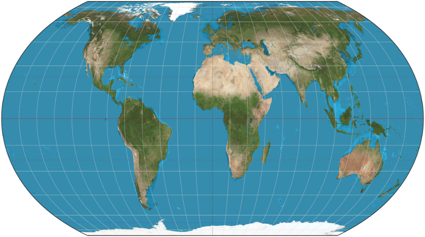
For centuries, the map hanging in classrooms, boardrooms, and newsrooms around the world has been lying to us, quietly, persistently, and almost nobody noticed. Africa, the second-largest continent on Earth, has spent generations looking like a slightly oversized Greenland. That distortion has now been formally challenged at the highest diplomatic table in the world.
On Friday, the United Nations General Assembly voted 164 to 1, with six abstentions, to adopt a resolution urging member states, schools, media houses and tech companies to move away from the centuries-old Mercator map in favour of projections that show the true size of continents. The United States cast the lone vote against it. The resolution, titled “Correct the Map,” was sponsored by African Union member states, led by Togo, alongside the Bahamas, and it marks the first time a UN body has formally taken a position on how the world literally sees itself.
It sounds like a small, almost academic argument about cartography. It isn’t. As Togo’s Foreign Minister, Robert Dussey, put it to reporters at UN headquarters, “A fair map does not change the geography of the world, it changes how we see the world.”
The Map Problem Nobody Questioned
The chart most of us grew up with is called the Mercator projection, designed in 1569 by the Flemish cartographer Gerardus Mercator. It was never built to represent landmass fairly, it was built for sailors, to preserve accurate angles and coastlines for sea navigation. The side effect, largely ignored for 450 years, is that it inflates the size of countries and regions far from the equator while shrinking those close to it.
The result: Canada and Greenland routinely appear roughly the same size as the entire African continent on classroom walls, in news broadcasts, and even inside the apps most of us check for driving directions. In reality, the numbers tell a completely different story.
| Landmass | Approx. Size (sq km) | What It Compares To |
|---|---|---|
| Africa | 30.3 million | Big enough to fit the US, China, India, and most of Europe combined |
| Greenland | ~2.1 million | About 14 times smaller than Africa |
| Latin America | 20 million | Nearly two-thirds the size of Africa |
| South America alone | 17.8 million | Slightly larger than Russia’s mapped footprint under Mercator |
| Oceania | 8.5 million | Almost entirely made up of Australia |
| South Asia | 5.1 million | Smallest of the four regions highlighted, yet home to roughly a quarter of humanity |
On a Mercator map, none of that comes through. Africa looks modest. Europe looks dominant. Russia appears to swallow a third of the globe. The countries campaigning for change argue that this isn’t just an inconvenience for geography teachers, it has shaped how the world thinks about Africa’s economic weight, political relevance and place in global affairs for nearly half a millennium.
From a Grassroots Campaign to the UN Floor
The resolution didn’t appear out of nowhere. It’s the product of a campaign called “Correct the Map,” launched in April by two advocacy groups, Africa No Filter and Speak Up Africa, initially aimed at getting schools to switch their wall maps to the more accurate Equal Earth projection before pushing the message to international organisations and newsrooms.
“Correcting the map is not only an African issue. It is a matter of truth and accuracy that concerns the entire world,” said Fara Ndiaye, co-founder and deputy executive director of Speak Up Africa, adding that a shrunken Africa on the world map minimises how the continent’s demographic, economic and strategic weight is perceived internationally.
The African Union, representing all 55 member states, threw its weight behind the campaign on August 14, calling it a major milestone. From there, momentum built quickly toward Friday’s vote at the General Assembly.
Carlos Lopes, a professor at the University of Cape Town and one of the campaign’s most visible advocates, could barely contain his excitement once the votes were counted. “164 votes in favour! This is an emotional day for me,” he wrote on social media shortly after the announcement.
The New Map: Equal Earth
The resolution doesn’t just criticise the old system, it points to a replacement. The document specifically names the Equal Earth projection, created in 2018 by cartographers Bojan Šavrič, Bernhard Jenny and Tom Patterson, as “a relevant option for improving the accuracy of the cartographic representation of the world.”
Unlike Mercator, Equal Earth preserves the actual proportional size of every landmass, even if it slightly compromises the precision of shapes and angles, a trade-off its creators always intended for educational and general-reference use rather than navigation. Patterson said he never expected his 2018 side project to end up shaping a UN resolution eight years later: “Wow. When we created the Equal Earth projection, we never imagined this.”
Who Backed It, Who Didn’t
The scale of support surprised even seasoned UN watchers. France, one of the resolution’s co-sponsors, didn’t wait for the vote to act. French Foreign Minister Jean-Noël Barrot announced in a speech at the Sorbonne that his country’s foreign ministry would abandon the Mercator projection altogether “in favour of map representations tailored to specific uses, more faithful to actual surface areas, and in line with the recommendations of cartographers and scientists.”
Barrot didn’t mince words about why it mattered. “The United States, Russia and China take on a disproportionate visual prominence compared to Africa, Latin America or Southeast Asia,” he said. “Distortions eventually take root in perceptions… the time has come to correct them.”
The European Union also backed the resolution, as did the Caribbean Community, whose Reparations Commission vice chair, Dorbrene O’Marde, described Equal Earth as a rejection of what he called the Mercator map’s “ideology of power and dominance.”
Washington stood alone in opposition. The U.S. delegation dismissed the resolution as a “radical ideological project” and lobbied other member states to vote against it, an effort that failed to peel off any meaningful support.
To be clear, the UN vote doesn’t ban the Mercator map or force any country, publisher or tech company to change their maps overnight. Resolutions of this kind carry moral and diplomatic weight rather than binding legal force. What it does is put the world’s largest multilateral body on record, formally, in support of accurate map projections, a signal that campaigners hope will filter down into classrooms, atlases, news graphics and the mapping software billions of people use every day.
For Togo, which fronted the resolution on behalf of the African Group at the UN, the next battle is closer to home: getting the Equal Earth projection into national school curricula, starting with its own classrooms.
For the rest of the continent, the vote is being read as more than a cartography update. It’s being framed as a long-overdue correction to a distortion that shaped perception for nearly 500 years , one map at a time.
Maps are never neutral. They’re one of the first tools children use to understand where their country sits in the world, and for generations, that tool has understated Africa’s scale, population and significance. This resolution won’t rewrite a single border, but it aims to rewrite an impression that’s been baked into classrooms, newsrooms and boardrooms since the 16th century, and for a continent of 1.4 billion people spanning 30.3 million square kilometres, that impression has mattered more than most people ever stopped to notice.